The article written by Kevin Wolf, Nicolas Bellouin, and Olivier Boucher can be found at:
https://doi.org/10.5194/acp-24-5009-2024
Aviation contributes to global climate warming by being responsible for 2.5 to 2.6 % of the global carbon dioxide (CO2) emissions in 2018. However, CO2 is only partly responsible for the climatic effect of aviation. Further contributions to aviation-induced climate change stem from the by-products of fossil fuel combustion like nitrogen oxides (NOx) or sulphur dioxide (SO2). Currently, much effort is done to use alternative fuels, like hydrogen, to make aviation more environmentally friendly. However, burning fuels that contain hydrogen bonds, no matter whether of fossil or synthetic origin, will result in the emission of water vapour, which is contained in the exhaust. Subsequently, the exhaust water vapour can condense and lead to the formation of condensation trails, known as contrails. Such contrails are artificial, optically thin cirrus-like clouds that are known to have, on average, a net warming effect on global climate.
In the new study by Wolf et al., model simulations from ERA5 re-analysis provided by the European Centre for Medium-Range Weather Forecasts (ECMWF) and observations from the In-service Aircraft for a Global Observing System (IAGOS) were used to obtain climatologies of regions, where contrails are most likely to form and their relation to ambient conditions. The focus is on a region ranging from Eastern United States to central Europe.
Wolf et al. provides distributions of typical crossing distance through a contrail-prone area based on IAGOS measurements and ERA5 simulations of temperature and relative humidity. It was found that for IAGOS, 50 % of the crossings of persistent contrail regions are shorter than 9 km, while in ERA5 the median is 155 km.
Further, Wolf et al. assessed the morphology of persistent contrail formation regions in terms of size, orientation, major axis length, and aspect ratio of individual regions. Persistent contrail shape information might be relevant for economic decision making to re-route flights horizontally or vertically. Half of the persistent contrail regions are found to be smaller than 35000 km2 (at 200 hPa) and the median of the maximum dimension is shorter than 760 km (at 200 hPa). Furthermore, these regions tend to be of near-circular shape with a tendency to a slight oval shape and a preferred alignment along the dominant westerly flow.
Seasonal, vertical distributions of the persistent contrail formation potential are information that could be used by airlines to assess the distance they would need to reroute on average. A seasonal overview is given in the figure below. The analysis provides a general perspective of the temporal and spatial distribution of these regions in ERA5. It shows that vertical distributions of persistent contrail formation are characterized by a maximum between 250 and 200 hPa. The horizontal distribution of these regions suggests that they are likely to appear in the same location on adjacent pressure levels.
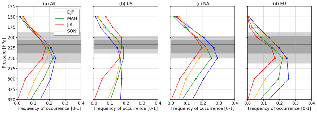
In addition to that, temperature, relative humidity and wind speed are studied to identify their effects on related persistent contrail formation. Persistent contrail formation is primarily limited by too warm conditions below and too dry conditions above the formation region. The distribution of persistent contrails is slanted towards lower altitudes from 30° N to 70° N, following lines of constant temperature and relative humidity. For an observed co-location of high wind speed and high persistent contrail formation, it remains unclear whether persistent contrail and the jet stream are favoured by the same meteorological conditions or if the jet stream itself favours persistent contrail occurrence. The analysis suggests that some persistent contrail regions will be difficult to avoid by rerouting aircraft due to their large vertical and horizontal extents.